GeoCoords:
Latitude: 33.022305000000
Longitude: -98.668055000000
Longitude: -98.668055000000
County:
- Young
Date:
Early June, 1849
Time Period:
Description:
A party of emigrants bound for California is involved in an engagement with the Wichita Indians near the Clear Fork of the Brazos River, thirty-six miles east of present-day Mineral Wells. Ten Indians and two emigrants are reported killed.
Event Type:
Race or Ethnicity:
Tribe:
Age:
adult (18+)
Citation:
Democratic Telegraph and Texas Register, June 28, 1849
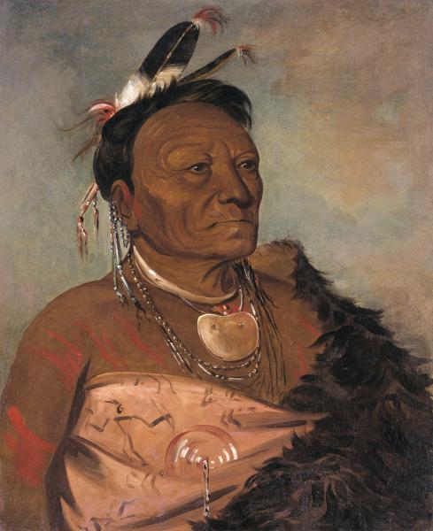 Wichita Indian
 Original Title: Wee-tá-ra-shá-ro, Head Chief of the Tribe
Image Type: Oil on canvas
Creator: George Catlin, 1834
Collection: Smithsonian American Art Museum, Gift of Mrs. Joseph Harrison, Jr.
Image Viewed: https://americanart.si.edu/artwork/wee-ta-ra-sha-ro-head-chief-tribe-4451
Image Accessed: April 9, 2019
GeoCoords:
Latitude: 33.022305000000
Longitude: -98.668055000000
Longitude: -98.668055000000
County:
- Young
Date:
Early June, 1849
Event Description:
A party of emigrants bound for California is involved in an engagement with the Wichita Indians near the Clear Fork of the Brazos River, thirty-six miles east of present-day Mineral Wells. Ten Indians and two emigrants are reported killed.
Event Type:
Tribe:
- Wichitas
Age:
adult (18+)
Citation:
Democratic Telegraph and Texas Register, June 28, 1849
Wichita Indian Original Title: Wee-tá-ra-shá-ro, Head Chief of the Tribe
Image Type: Oil on canvas
Creator: George Catlin, 1834
Collection: Smithsonian American Art Museum, Gift of Mrs. Joseph Harrison, Jr.
Image Viewed: https://americanart.si.edu/artwork/wee-ta-ra-sha-ro-head-chief-tribe-4451
Image Accessed: April 9, 2019