
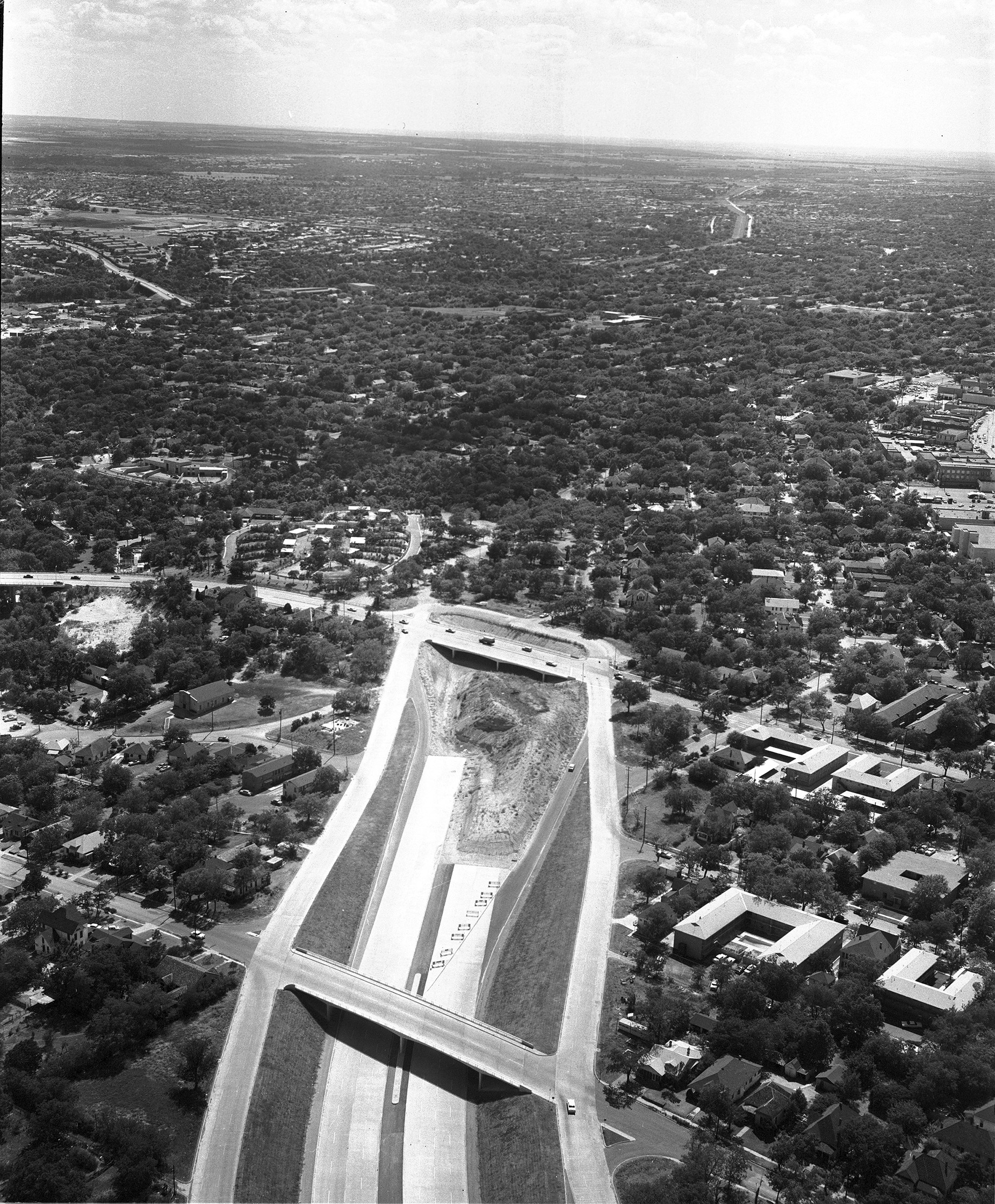
Aerial of end of freeway construction of the R. L. Thornton and Stemmons expressways, Dallas, Texas. The construction of the R. L. Thornton Freeway (I-35E) cut through the Tenth Street neighborhood. Construction had proceeded as far as the intersection with Marsalis Avenue, severing connections to Oak Cliff to the east and isolating the neighborhood between the Thornton and South freeways (I-35E and I-45).
Item: An aerial of the end of freeway construction of the R. L. Thornton and Stemmons expressways, Dallas, Texas
APA
Squire Haskins Photography, Inc. Collection, University of Texas at Arlington Libraries. An aerial of the end of freeway construction of the R. L. Thornton and Stemmons expressways, Dallas, Texas. (1959). Retrieved from https://library.uta.edu/digitalgallery/img/10006343Chicago/Turabian
Squire Haskins Photography, Inc. Collection, University of Texas at Arlington Libraries. "An aerial of the end of freeway construction of the R. L. Thornton and Stemmons expressways, Dallas, Texas." UTA Libraries Digital Gallery. 1959. AccessedApril 28, 2024
MLA
Squire Haskins Photography, Inc. Collection, University of Texas at Arlington Libraries. An aerial of the end of freeway construction of the R. L. Thornton and Stemmons expressways, Dallas, Texas. 1959. UTA Libraries Digital Gallery, https://library.uta.edu/digitalgallery/img/10006343. Accessed28 Apr 2024
Special Collections Reference Information
Original image part of the Squire Haskins Photography, Inc. Collection, University of Texas at Arlington Libraries. Identifier: AR447 A3924 [frame #7]
Identifier: 10006343
Title: An aerial of the end of freeway construction of the R. L. Thornton and Stemmons expressways, Dallas, Texas
Creator: Squire Haskins Photography, Inc. (Photographer)
Description: Aerial of end of freeway construction of the R. L. Thornton and Stemmons expressways, Dallas, Texas. The construction of the R. L. Thornton Freeway (I-35E) cut through the Tenth Street neighborhood. Construction had proceeded as far as the intersection with Marsalis Avenue, severing connections to Oak Cliff to the east and isolating the neighborhood between the Thornton and South freeways (I-35E and I-45).
Date Created: 1959-08-01
Coverage: 1950s
Category: Architecture, Art and Culture, Cartography - Maps and Atlases, Cities and Towns, Photography Collections
Subject Term: Cityscapes, Roads, Toll roads, Trees, Buildings, Houses
Location: Dallas (Tex.)
Collection: Squire Haskins Photography, Inc. Collection
Type: Still Image
Format: JPG
Publisher: University of Texas at Arlington Libraries
Rights Holder: University of Texas at Arlington Libraries, Special Collections
Rights:
License:
Title: An aerial of the end of freeway construction of the R. L. Thornton and Stemmons expressways, Dallas, Texas
Creator: Squire Haskins Photography, Inc. (Photographer)
Description: Aerial of end of freeway construction of the R. L. Thornton and Stemmons expressways, Dallas, Texas. The construction of the R. L. Thornton Freeway (I-35E) cut through the Tenth Street neighborhood. Construction had proceeded as far as the intersection with Marsalis Avenue, severing connections to Oak Cliff to the east and isolating the neighborhood between the Thornton and South freeways (I-35E and I-45).
Date Created: 1959-08-01
Coverage: 1950s
Category: Architecture, Art and Culture, Cartography - Maps and Atlases, Cities and Towns, Photography Collections
Subject Term: Cityscapes, Roads, Toll roads, Trees, Buildings, Houses
Location: Dallas (Tex.)
Collection: Squire Haskins Photography, Inc. Collection
Type: Still Image
Format: JPG
Publisher: University of Texas at Arlington Libraries
Rights Holder: University of Texas at Arlington Libraries, Special Collections
Rights:
Any use of content downloaded or printed from this site is limited to non-commercial personal or educational use, including fair use as directed by U.S. copyright laws. For more information or for reproduction requests, please contact Special Collections at The University of Texas at Arlington Libraries by emailing spcoref@uta.edu.
License:
Attribution-NonCommercial 4.0 International (CC BY-NC 4.0) http://creativecommons.org/licenses/by-nc/4.0/ If used, please attribute using one of the citations provided.
Harmful Content Statement: This item includes content that may have outdated language or may be graphic or disturbing in nature. Please refer to our Statement of Harmful Language for more information.