
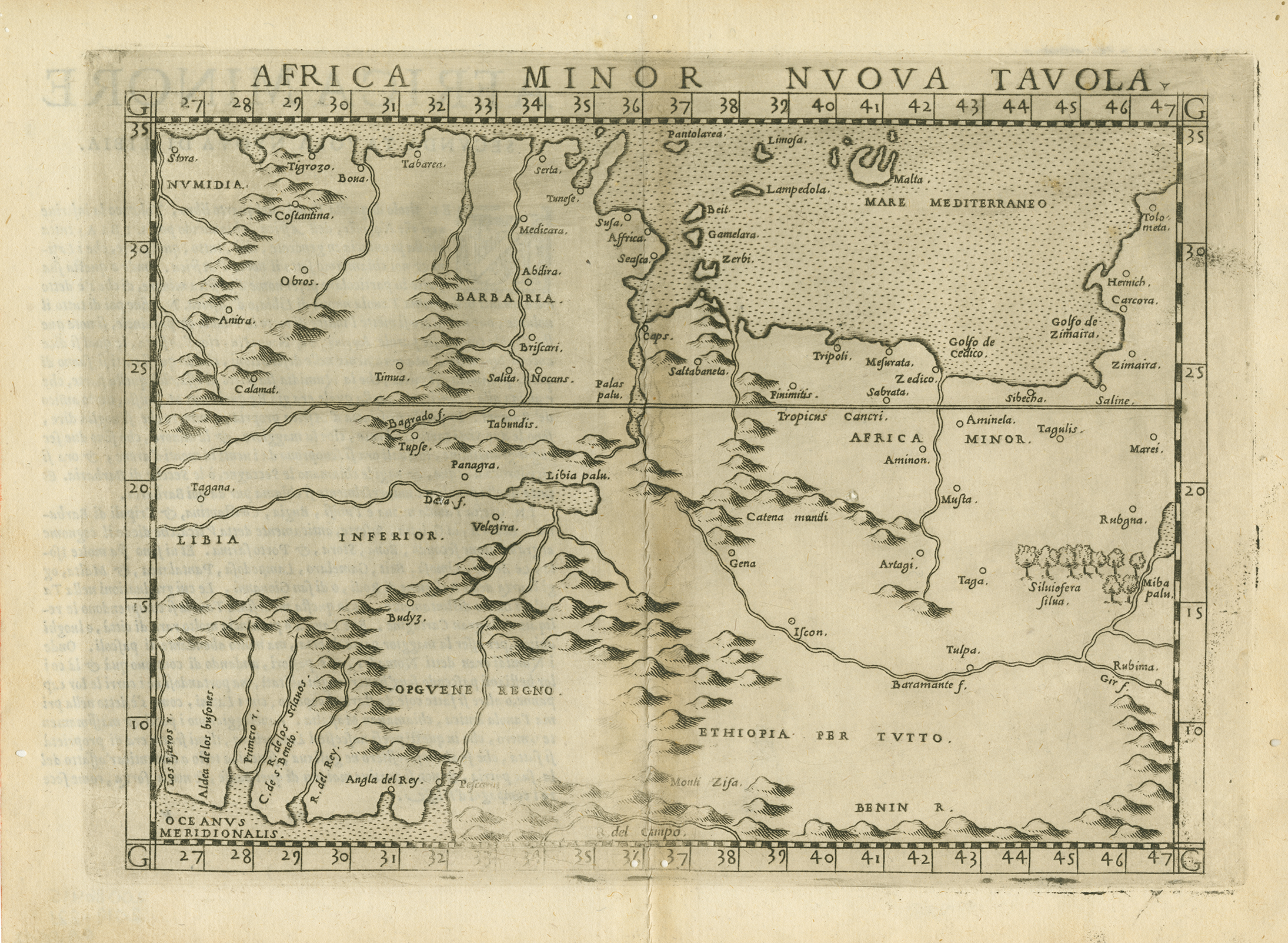
Girolamo Ruscelli's "modern" or updated map of the central portion of northern Africa first appeared in his updated 1561 edition of second-century Greek geographer Claudius Ptolemy's Geography. It shows the region from "Numidia" to "Tolometa" or, roughly present eastern Algeria, Tunisia, and western Libya as far east as Benghazi. It also shows part of the Guinea coast in the bottom left corner. Malta and Lampedusa are among several islands featured in the Mediterranean. Ruscelli's geography was an expanded edition of fellow Venetian Giacomo Gastaldi's 1548 edition of Ptolemy's geography and Ruscelli's maps were just a little larger than those of Gastaldi; otherwise, there was usually little difference on first glance. Gastaldi's work has been called the most comprehensive atlas produced between Martin Waldseemüller's geography of 1513, and the Abraham Ortelius atlas of 1570. Both Ruscelli and Gastaldi's maps were beautifully engraved on copper, marking a turning point in the history of cartography. From that point forward, the majority of cartographic works used this medium. The copper plate was easier to incise than cutting into wood and it thus gave the engraver the ability to render more detail while also producing more copies. Revisions and changes were also much easier as portions of the plate could be hammered smooth and re-cut with ease.
Horizontal map. Double sided, single paged with fold in middle (no binding). Full text on right side of page, left side blank, and map on reverse side of full page. Visible offsetting of map against page. 22 cm. x 29 cm.
[Gift of Dr. Jack Franke]
Item: Africa Minor Nuova Tabula
APA
Maps of Africa, University of Texas at Arlington Libraries. Africa Minor Nuova Tabula. (1574). Retrieved from https://library.uta.edu/digitalgallery/img/20086415Chicago/Turabian
Maps of Africa, University of Texas at Arlington Libraries. "Africa Minor Nuova Tabula." UTA Libraries Digital Gallery. 1574. AccessedApril 28, 2024
MLA
Maps of Africa, University of Texas at Arlington Libraries. Africa Minor Nuova Tabula. 1574. UTA Libraries Digital Gallery, https://library.uta.edu/digitalgallery/img/20086415. Accessed28 Apr 2024
Special Collections Reference Information
Original image part of the Maps of Africa, University of Texas at Arlington Libraries. Identifier: 2019-221, Ruscelli_AfricaMinorNuovaTabula_1574_UTA_2019-221
Identifier: 20086415
Title: Africa Minor Nuova Tabula
Creator: Ruscelli, Girolamo (Cartographer, Publisher), Ptolemy, Claudius (Geographer)
Description: Girolamo Ruscelli's "modern" or updated map of the central portion of northern Africa first appeared in his updated 1561 edition of second-century Greek geographer Claudius Ptolemy's Geography. It shows the region from "Numidia" to "Tolometa" or, roughly present eastern Algeria, Tunisia, and western Libya as far east as Benghazi. It also shows part of the Guinea coast in the bottom left corner. Malta and Lampedusa are among several islands featured in the Mediterranean. Ruscelli's geography was an expanded edition of fellow Venetian Giacomo Gastaldi's 1548 edition of Ptolemy's geography and Ruscelli's maps were just a little larger than those of Gastaldi; otherwise, there was usually little difference on first glance. Gastaldi's work has been called the most comprehensive atlas produced between Martin Waldseemüller's geography of 1513, and the Abraham Ortelius atlas of 1570. Both Ruscelli and Gastaldi's maps were beautifully engraved on copper, marking a turning point in the history of cartography. From that point forward, the majority of cartographic works used this medium. The copper plate was easier to incise than cutting into wood and it thus gave the engraver the ability to render more detail while also producing more copies. Revisions and changes were also much easier as portions of the plate could be hammered smooth and re-cut with ease. Horizontal map. Double sided, single paged with fold in middle (no binding). Full text on right side of page, left side blank, and map on reverse side of full page. Visible offsetting of map against page. 22 cm. x 29 cm. [Gift of Dr. Jack Franke]
Date Created: 1574
Coverage: 1550s
Category: Cartography - Maps and Atlases
Subject Term: Maps, Africa, Numidia, Malta, Tunisia, Libya, North Africa, copperplate engraving
Location: Africa
Collection: Maps of Africa
Language: Italian
Type: Still Image
Format: JPG
Publisher: University of Texas at Arlington Libraries
Rights Holder: University of Texas at Arlington Libraries, Special Collections
Rights:
License:
Title: Africa Minor Nuova Tabula
Creator: Ruscelli, Girolamo (Cartographer, Publisher), Ptolemy, Claudius (Geographer)
Description: Girolamo Ruscelli's "modern" or updated map of the central portion of northern Africa first appeared in his updated 1561 edition of second-century Greek geographer Claudius Ptolemy's Geography. It shows the region from "Numidia" to "Tolometa" or, roughly present eastern Algeria, Tunisia, and western Libya as far east as Benghazi. It also shows part of the Guinea coast in the bottom left corner. Malta and Lampedusa are among several islands featured in the Mediterranean. Ruscelli's geography was an expanded edition of fellow Venetian Giacomo Gastaldi's 1548 edition of Ptolemy's geography and Ruscelli's maps were just a little larger than those of Gastaldi; otherwise, there was usually little difference on first glance. Gastaldi's work has been called the most comprehensive atlas produced between Martin Waldseemüller's geography of 1513, and the Abraham Ortelius atlas of 1570. Both Ruscelli and Gastaldi's maps were beautifully engraved on copper, marking a turning point in the history of cartography. From that point forward, the majority of cartographic works used this medium. The copper plate was easier to incise than cutting into wood and it thus gave the engraver the ability to render more detail while also producing more copies. Revisions and changes were also much easier as portions of the plate could be hammered smooth and re-cut with ease. Horizontal map. Double sided, single paged with fold in middle (no binding). Full text on right side of page, left side blank, and map on reverse side of full page. Visible offsetting of map against page. 22 cm. x 29 cm. [Gift of Dr. Jack Franke]
Date Created: 1574
Coverage: 1550s
Category: Cartography - Maps and Atlases
Subject Term: Maps, Africa, Numidia, Malta, Tunisia, Libya, North Africa, copperplate engraving
Location: Africa
Collection: Maps of Africa
Language: Italian
Type: Still Image
Format: JPG
Publisher: University of Texas at Arlington Libraries
Rights Holder: University of Texas at Arlington Libraries, Special Collections
Rights:
Any use of content downloaded or printed from this site is limited to non-commercial personal or educational use, including fair use as directed by U.S. copyright laws. For more information or for reproduction requests, please contact Special Collections at The University of Texas at Arlington Libraries by emailing spcoref@uta.edu.
License:
Attribution-NonCommercial 4.0 International (CC BY-NC 4.0) http://creativecommons.org/licenses/by-nc/4.0/ If used, please attribute using one of the citations provided.
Harmful Content Statement: This item includes content that may have outdated language or may be graphic or disturbing in nature. Please refer to our Statement of Harmful Language for more information.