
![L'afrique suivant les connaissances géographiques actuelles [map of Africa]](https://library.uta.edu/digitalgallery/sites/library.uta.edu.digitalgallery/files/20080000-20089999/20086434.jpg)
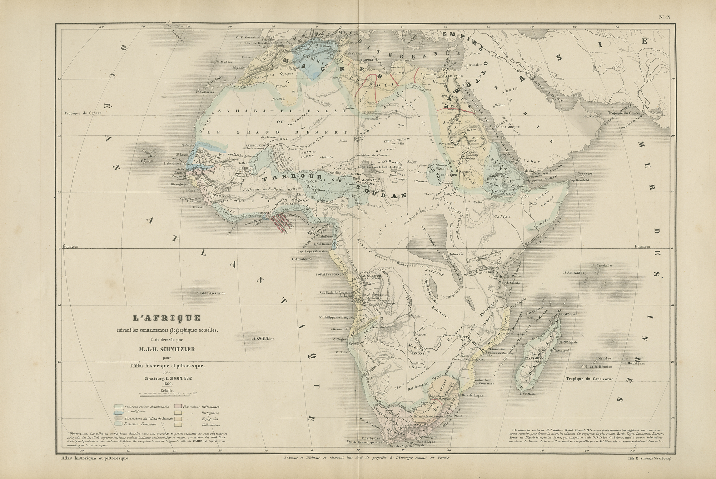
Titled: "Africa following the current geographical knowledge." This old and authentic map represents the continent of Africa. Note the large poorly charted areas and errors. The most egregious is this famous Lake "Oukérévé" or Lake Victoria. Jean-Henri Schnitzler, born in Strasbourg in 1802, was a great Alsatian historian and keen on statistics. Professor in Russia for nearly 5 years, he knew this area very well and was the author of numerous books on this Empire. His maps testify to his love of history and statistics: they include a large number of mostly historical information, but are simple and easy to read. Verso is blank. 37 cm. x 56 cm. [Gift of Dr. Jack Franke]
Item: L'afrique suivant les connaissances géographiques actuelles
APA
Maps of Africa, University of Texas at Arlington Libraries. L'afrique suivant les connaissances géographiques actuelles. (1860). Retrieved from https://library.uta.edu/digitalgallery/img/20086434Chicago/Turabian
Maps of Africa, University of Texas at Arlington Libraries. "L'afrique suivant les connaissances géographiques actuelles." UTA Libraries Digital Gallery. 1860. AccessedApril 28, 2024
MLA
Maps of Africa, University of Texas at Arlington Libraries. L'afrique suivant les connaissances géographiques actuelles. 1860. UTA Libraries Digital Gallery, https://library.uta.edu/digitalgallery/img/20086434. Accessed28 Apr 2024
Special Collections Reference Information
Original image part of the Maps of Africa, University of Texas at Arlington Libraries. Identifier: 2019-375, Schnitzler_L'afrique suivant les connaissances géographiques actuelles_1860_UTA_2019-375
Identifier: 20086434
Title: L'afrique suivant les connaissances géographiques actuelles
Creator: Schnitzler, Jean-Henri (Cartographer)
Description: Titled: "Africa following the current geographical knowledge." This old and authentic map represents the continent of Africa. Note the large poorly charted areas and errors. The most egregious is this famous Lake "Oukérévé" or Lake Victoria. Jean-Henri Schnitzler, born in Strasbourg in 1802, was a great Alsatian historian and keen on statistics. Professor in Russia for nearly 5 years, he knew this area very well and was the author of numerous books on this Empire. His maps testify to his love of history and statistics: they include a large number of mostly historical information, but are simple and easy to read. Verso is blank. 37 cm. x 56 cm. [Gift of Dr. Jack Franke]
Date Created: 1860
Coverage: 1860s
Category: Cartography - Maps and Atlases
Subject Term: Maps, Africa, Lake Victoria, Great lakes (Africa), Lake Oukérévé
Location: Africa
Collection: Maps of Africa
Language: French
Type: Still Image
Format: JPG
Publisher: University of Texas at Arlington Libraries
Rights Holder: University of Texas at Arlington Libraries, Special Collections
Rights:
License:
Title: L'afrique suivant les connaissances géographiques actuelles
Creator: Schnitzler, Jean-Henri (Cartographer)
Description: Titled: "Africa following the current geographical knowledge." This old and authentic map represents the continent of Africa. Note the large poorly charted areas and errors. The most egregious is this famous Lake "Oukérévé" or Lake Victoria. Jean-Henri Schnitzler, born in Strasbourg in 1802, was a great Alsatian historian and keen on statistics. Professor in Russia for nearly 5 years, he knew this area very well and was the author of numerous books on this Empire. His maps testify to his love of history and statistics: they include a large number of mostly historical information, but are simple and easy to read. Verso is blank. 37 cm. x 56 cm. [Gift of Dr. Jack Franke]
Date Created: 1860
Coverage: 1860s
Category: Cartography - Maps and Atlases
Subject Term: Maps, Africa, Lake Victoria, Great lakes (Africa), Lake Oukérévé
Location: Africa
Collection: Maps of Africa
Language: French
Type: Still Image
Format: JPG
Publisher: University of Texas at Arlington Libraries
Rights Holder: University of Texas at Arlington Libraries, Special Collections
Rights:
Any use of content downloaded or printed from this site is limited to non-commercial personal or educational use, including fair use as directed by U.S. copyright laws. For more information or for reproduction requests, please contact Special Collections at The University of Texas at Arlington Libraries by emailing spcoref@uta.edu.
License:
Attribution-NonCommercial 4.0 International (CC BY-NC 4.0) http://creativecommons.org/licenses/by-nc/4.0/ If used, please attribute using one of the citations provided.
Harmful Content Statement: This item includes content that may have outdated language or may be graphic or disturbing in nature. Please refer to our Statement of Harmful Language for more information.