
2018-01-18
Description:
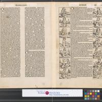
Schedel's map is one of the earliest obtainable world maps, and, visually, one of the most evocative of its period. Published just 40 years after the invention of printing, the Schedel map presents the world as seen just prior to Columbus' voyage and the rounding of the Cape of Good Hope by Dias. The engraving also reveals the medieval attitude toward peoples of distant lands through the grotesque creatures found on both sides; these creatures were believed to inhabit unexplored areas. This helps to explain the ease with which Europeans were able to demonize indigenous peoples they encountered in the New World.
Shirley, Mapping of the World, No. 19, pl. 25; The World Encompassed, No. 44.
On verso: three columns of Latin text with the third column bordered by a panel of seven creatures on either side; upper right: "folium XII.
Item File:
Topic:
Keywords:
Creator:
Schedel, Hartmann, 1440-1514
Date Created:
Image Type:
Language:
English (United States)
Identifier:
20034133
Call Number:
Special Collections Map Room Bin 13 220004
Publisher:
University of Texas at Arlington
Rights:
Any use of content downloaded or printed from this site is limited to non-commercial personal or educational use, including fair use as directed by U.S. copyright laws. For more information, high resolution reproduction requests, or for commercial use please contact Special Collections at The University of Texas at Arlington Libraries.
Rights Holder:
University of Texas at Arlington Libraries, Special Collections
License:
Attribution-NonCommercial 4.0 International (CC BY-NC 4.0)