GeoCoords:
Latitude: 27.368764000000
Longitude: -98.190841000000
Longitude: -98.190841000000
County:
- Jim Wells
Date:
1844
Time Period:
Description:
A company of Mexican defensores (militia) led by Capt. Trinidad Aldrete attacks a group of Karankawa Indians, 50 miles southwest of Corpus Christi.
Event Type:
Race or Ethnicity:
Tribe:
Age:
adult (18+)
Citation:
Hobart Huson, Refugio: A Comprehensive History of Refugio County from Aboriginal Times to 1953 (Rooke Foundation, 1953), 1:44.
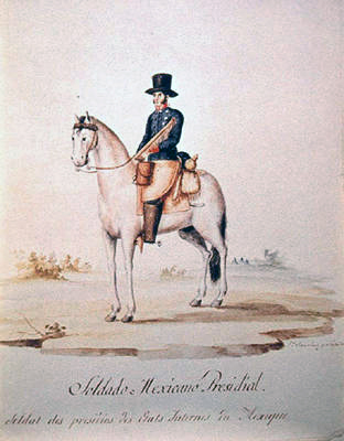 Presidial Soldier
 Original Title: Solodado Mexican Persidial. Soldat des presilos des Etats Internes du Mixique
Image Type: Watercolor and ink on paper
Creator: Lino Sánchez y Tapia
Collection: Thomas W. Gilcrease Museum, Tulsa, Oklahoma
Image Citation:
Berlandier, Jean Louis, The Indians of Texas in 1830. Washington, D.C.: Smithsonian Press, 1969, Plate 14
GeoCoords:
Latitude: 27.368764000000
Longitude: -98.190841000000
Longitude: -98.190841000000
County:
- Jim Wells
Date:
1844
Event Description:
A company of Mexican defensores (militia) led by Capt. Trinidad Aldrete attacks a group of Karankawa Indians, 50 miles southwest of Corpus Christi.
Event Type:
Tribe:
- Karankawas
Age:
adult (18+)
Citation:
Hobart Huson, Refugio: A Comprehensive History of Refugio County from Aboriginal Times to 1953 (Rooke Foundation, 1953), 1:44.
Presidial Soldier Original Title: Solodado Mexican Persidial. Soldat des presilos des Etats Internes du Mixique
Image Type: Watercolor and ink on paper
Creator: Lino Sánchez y Tapia
Collection: Thomas W. Gilcrease Museum, Tulsa, Oklahoma
Image Citation:
Berlandier, Jean Louis, The Indians of Texas in 1830. Washington, D.C.: Smithsonian Press, 1969, Plate 14