
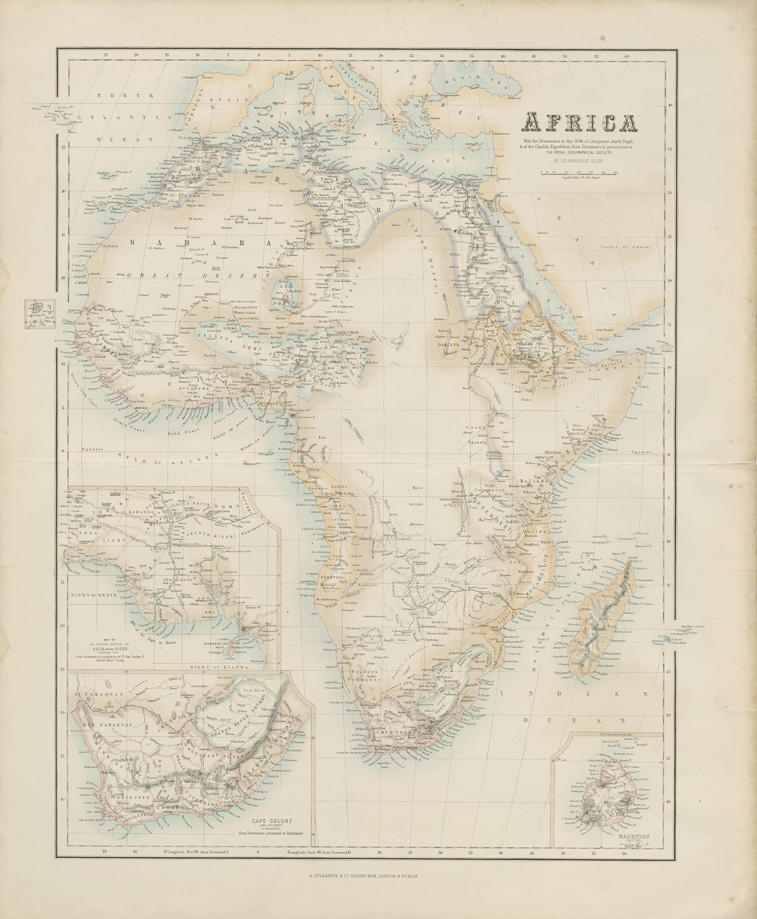
Detailed double map by G. H. Swanston, with insert maps of Mauritius, Cape Colony, and Delta of the Niger published by Archibald Fullarton with his 'Royal Illustrated Atlas,' Edinburgh circa 1874. Map shows the extent of European discoveries and geographical knowledge in the middle of the 19th century.
Fullarton's 'Royal Illustrated Atlas,' the last highly decorative atlas published in England. Even the maps without views or figures are beautifully engraved and colored with a mixture of printed color and hand color. Swanston, Petermann, Bartholomew, Macnab and Johnson engraved the maps. The maps bear a superficial resemblance to Keith Johnston's Royal Atlas. Fullarton frequently gives the sources for his maps - for the United States maps he gives Calvin Smith and Tanner as sources. 52 cm. x 41 cm. [Gift of Dr. Jack Franke]
Item: Africa, with the discoveries to May 1858 of Livingstone, Barth, Vogel, & of the Chadda Expedition from Documents in possession of the Royal Geographical Society
APA
Maps of Africa, University of Texas at Arlington Libraries. Africa, with the discoveries to May 1858 of Livingstone, Barth, Vogel, & of the Chadda Expedition from Documents in possession of the Royal Geographical Society. (1874). Retrieved from https://library.uta.edu/digitalgallery/img/20086448Chicago/Turabian
Maps of Africa, University of Texas at Arlington Libraries. "Africa, with the discoveries to May 1858 of Livingstone, Barth, Vogel, & of the Chadda Expedition from Documents in possession of the Royal Geographical Society." UTA Libraries Digital Gallery. 1874. AccessedApril 28, 2024
MLA
Maps of Africa, University of Texas at Arlington Libraries. Africa, with the discoveries to May 1858 of Livingstone, Barth, Vogel, & of the Chadda Expedition from Documents in possession of the Royal Geographical Society. 1874. UTA Libraries Digital Gallery, https://library.uta.edu/digitalgallery/img/20086448. Accessed28 Apr 2024
Special Collections Reference Information
Original image part of the Maps of Africa, University of Texas at Arlington Libraries. Identifier: 2019-198, Swanston and Fullarton_Africa_1874_UTA_2019-198
Identifier: 20086448
Title: Africa, with the discoveries to May 1858 of Livingstone, Barth, Vogel, & of the Chadda Expedition from Documents in possession of the Royal Geographical Society
Creator: Swanston, G. H. (Cartographer), Fullarton, Archibald (Publisher)
Description: Detailed double map by G. H. Swanston, with insert maps of Mauritius, Cape Colony, and Delta of the Niger published by Archibald Fullarton with his 'Royal Illustrated Atlas,' Edinburgh circa 1874. Map shows the extent of European discoveries and geographical knowledge in the middle of the 19th century. Fullarton's 'Royal Illustrated Atlas,' the last highly decorative atlas published in England. Even the maps without views or figures are beautifully engraved and colored with a mixture of printed color and hand color. Swanston, Petermann, Bartholomew, Macnab and Johnson engraved the maps. The maps bear a superficial resemblance to Keith Johnston's Royal Atlas. Fullarton frequently gives the sources for his maps - for the United States maps he gives Calvin Smith and Tanner as sources. 52 cm. x 41 cm. [Gift of Dr. Jack Franke]
Date Created: 1874
Coverage: 1870s
Category: Cartography - Maps and Atlases
Subject Term: Maps, Africa
Location: Africa
Collection: Maps of Africa
Language: English
Type: Still Image
Format: JPG
Publisher: University of Texas at Arlington Libraries
Rights Holder: University of Texas at Arlington Libraries, Special Collections
Rights:
License:
Title: Africa, with the discoveries to May 1858 of Livingstone, Barth, Vogel, & of the Chadda Expedition from Documents in possession of the Royal Geographical Society
Creator: Swanston, G. H. (Cartographer), Fullarton, Archibald (Publisher)
Description: Detailed double map by G. H. Swanston, with insert maps of Mauritius, Cape Colony, and Delta of the Niger published by Archibald Fullarton with his 'Royal Illustrated Atlas,' Edinburgh circa 1874. Map shows the extent of European discoveries and geographical knowledge in the middle of the 19th century. Fullarton's 'Royal Illustrated Atlas,' the last highly decorative atlas published in England. Even the maps without views or figures are beautifully engraved and colored with a mixture of printed color and hand color. Swanston, Petermann, Bartholomew, Macnab and Johnson engraved the maps. The maps bear a superficial resemblance to Keith Johnston's Royal Atlas. Fullarton frequently gives the sources for his maps - for the United States maps he gives Calvin Smith and Tanner as sources. 52 cm. x 41 cm. [Gift of Dr. Jack Franke]
Date Created: 1874
Coverage: 1870s
Category: Cartography - Maps and Atlases
Subject Term: Maps, Africa
Location: Africa
Collection: Maps of Africa
Language: English
Type: Still Image
Format: JPG
Publisher: University of Texas at Arlington Libraries
Rights Holder: University of Texas at Arlington Libraries, Special Collections
Rights:
Any use of content downloaded or printed from this site is limited to non-commercial personal or educational use, including fair use as directed by U.S. copyright laws. For more information or for reproduction requests, please contact Special Collections at The University of Texas at Arlington Libraries by emailing spcoref@uta.edu.
License:
Attribution-NonCommercial 4.0 International (CC BY-NC 4.0) http://creativecommons.org/licenses/by-nc/4.0/ If used, please attribute using one of the citations provided.
Harmful Content Statement: This item includes content that may have outdated language or may be graphic or disturbing in nature. Please refer to our Statement of Harmful Language for more information.